|
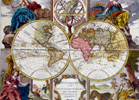
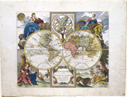
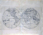
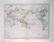
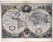
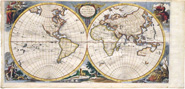
EVOLUTION OF THE MAP OF THE WORLD Every moment of history has its map. The evolution of the world map corresponds to very different times for many years. From the year 600 a.C. Until now, it has been tried to represent different types of maps according to what was thought to be the world at that moment. Each story has its map, each geographical and astronomical discovery has been represented; each war, they created their strategies from a map of the area; every treasure, not only pirate, also to find El Dorado, Atahualpa's gold, during the conquests and even in World War II. EVOLUTION OF THE MAP OF THE WORLD, FROM BABYLON TO THE PRESENT DAY BEFORE CHRIST, FROM BABYLON TO ALEXANDRIA Probably maps have been created for thousands of years, but the first sign of a map of the world we have to go back to 600 a.C. to ancient Babylon. A tablet made of clay in which seven cities are represented on the mainland, ocean, and islands. The following map of which we have record is located in the year 590 a.C. created by the Greek geographer Anaximander Mileto. A circular map showing Europe up, Asia down in the center of the Mediterranean Sea and around the ocean. Greece, Italy, Spain, Egypt, Libya, Arabia, Persia, Assyria or Palestine were already represented on this world map. From Greece, we moved to ancient Alexandria, where a librarian named Eratosthenes of Cyrene in 194 BC. He was the first to use parallels and meridians on a map. The point at which these two lines cross (parallel and meridian) was the city of Rhodes. Interconnected oceans and countries like Arabia, Libya, India, Persian Empire, Sri Lanka or Great Britain, is what Eratosthenes proposed on his map. AFTER CHRIST, FROM THE GRECO-ROMAN EMPIRE TO THE PRESENT DAY After an infinity of maps, the cartography was updated through new discoveries. You get to the representation of latitudes and longitudes on the map of Ptolemy. The Greek philosopher in the year 150 approximately, created this map with certain distortions, but great precision in other cities corresponding to the Greco-Roman Empire. Stories and more stories of war, conquests, searches ... We arrived in the 12th century with the creation of the Rogerian Tabula by the geographer Muhammad al-Idrisi. A more updated map in which you can see more details with Spain, Italy, Great Britain, Ireland, the Nile River, the Red Sea, Europe, the Middle East and North Africa. THE 16TH CENTURY A JUMP TO CURRENT REPRESENTATION We jump and change the century until the 16th century. A map created in the year 1500 by Juan de la Cosa, a pilot of one of the Caravels, the Santa María. On the map, you can see the map of the Old and the New World with details and color. With great precision, it was drawn from navigation charts and the memory of the Cantabrian Juan de la Cosa. In 1507 a German cartographer, Martin Waldseemüller created what we call the first world map with the new continent that they called America. It was created from data of Amerigo Vespucci during his travels in 1501 and 1502. 20 years later, Diego Ribeiro, a Portuguese cartographer created for Spain the first scientific map of the world in 1527. It draws accurately the coasts of Central and South America, in turn, defines the extent of the Pacific Ocean. Just over 40 years later, the Dutch cartographer Gerardus Mercator creates the atlas with the image of the world we know today. It can be said that Mercator was the founder of modern cartography. A map for navigation, through the latitudinal repetition, representing the world in a single plane. A complete map with a cylindrical representation and with distortions in higher elevation latitudes.
|